Decorative animation: a slowly drifting field of depth-contour lines with a survey track and a marker travelling along it. Moving the pointer over it shows a simulated instrument readout.
Georeferenced survey software · Self-hosted
Every frame on the map
Benthos takes the video, positioning and terrain your team already captures and turns it into one navigable, annotated, exportable survey. Born in deep-sea benthic biology. Built for any hard-to-reach place.
Licensed per installation, unlimited users. Your data stays on your servers.
01 The viewer
One survey, one picture
This is the Benthos viewer as your team uses it: map, video, dive profile and 3D terrain, always in sync. Try it right here, on a recreated survey 780 m down.
 Benthos
North Atlantic — coral mound (recreation)
Simulated data
Map pane: the ROV track over a coral mound, coloured by depth, with six annotations: points, a stretch and an area. The marker follows the video. Drag to pan; the buttons zoom.
Video pane: recreated ROV footage of a cold-water coral mound at 780 m, played in sync with the map and the timeline.
The 3D view needs WebGL, which this browser has turned off.
Everything follows the video: map, data panel, profile and 3D. Click the map or the profile and the video jumps. Open “3D terrain”: it comes up in its own window, which you can move and resize.Recreation · real species
02 Environments
Same engine, any environment
Benthos does not care what carried the camera. An ROV in a trench, a diver along a wall, a team crawling a lava tube with no satellite fix. If there is footage, a track and a surface, Benthos puts them together.
780 m. An ROV transect over a cold-water coral mound. Follow the track, stop on a colony, annotate it, export the point.
No GPS underground. Position comes from the survey itself. The engine does not notice the difference.
Under the ice shelf, the ROV cannot see a single satellite. Track from acoustic positioning, video of the underside of the ice, the same map.
Under the canopy the GPS drifts and the ground is hidden. A LiDAR survey reveals the terrain; Benthos puts the footage and the track on it.
Deep in a canyon the GPS loses satellites and bounces off the walls. The flight video and the terrain model place the track, and every wall stays where it is, layer by layer.
A drone over a fresh lava flow: too hot to walk, too steep to map by hand. Flight video, flight track and a photogrammetric surface, together.
And why not? There is footage, a track and terrain to map there too — only on regolith. Wherever people manage to go, Benthos can follow.
There is no GPS on the Moon. The rover places itself by visual odometry against a terrain model made from orbit; at the south pole, craters in permanent shadow hold water ice no one has seen yet.
Field note A cold-water coral reef grows a few millimetres a year, and a mound like this one can take thousands of years to form. Coming back to the same spot survey after survey, with earlier annotations in view, turns every visit into a time series.Field note In Lanzarote, the Atlantis Tunnel runs more than 1.5 km under the sea: the longest submarine lava tube known. Out there every metre of footage costs a technical dive, so it deserves to stay pinned to its exact spot for good.Field note A polar expedition means weeks at sea for a few hours of ROV time under the ice. What is filmed in that window has to be reviewed, annotated and shared for years, by teams who may never set foot on the ice.Field note In the jungle, one track matters to botanists, entomologists and ornithologists alike. Each team annotates its own findings on the same footage and the same terrain, and it all ends up on one map.Field note Canyon walls are an open book: each layer is an era. Flash floods reshape the riverbed from one year to the next, but the rock stays put, a fixed reference for comparing survey after survey.Field note The Moon barely changes: a footprint can last millions of years. Whatever gets mapped there serves the missions that follow, which come back to the same crater with everything before already on the map.Field note After an eruption the ground changes within weeks: the cone grows, the flow advances, the lava delta pushes the coastline out to sea. With two flights over the same site, Benthos puts both 3D terrains side by side and the change is plain to see.Field note Perseverance has been roving Jezero crater since 2021, photographing every rock it studies while knowing where it stands. It is the same job an ROV does, some 225 million kilometres away.
Recreated footage of the selected environment with a small contour map whose track follows the video. Moving the pointer over the map shows a simulated instrument readout.
03 How it works
Three steps. The first one you already do
No new hardware, no new protocol. Benthos starts from the recordings your team already brings back.
-
You do this
Step 01
Capture what you already capture
Video from ROV, AUV, diver, drone or handheld. Navigation from whatever positioning you use. Terrain if you have it.
-
Step 02
Ingest on your server
Benthos aligns the footage to the track, computes the predicted tide for the survey window offline, and stores everything in your institution's own installation.
-
Step 03
Navigate, annotate, export
Move along the real track with map and video in step. Annotate species and habitats against a controlled vocabulary. Export to GIS. Deliver with BenthosLite.
04 Capabilities
What it does today
Everything below runs in production. Items marked Roadmap are next.
Navigate
- Map and video kept in step, frame by frame.
- 3D terrain with up to four synchronised windows and a split mode to compare surveys or seasons.
- Runs on a modest laptop without exhausting the GPU.
- Field mode for the boat and the cave: it opens without a connection, downloads the data and video of each track and lets you annotate offline. Everything syncs when the connection is back.
Annotate
- Bionomic and species annotation tied to a position and a moment.
- Controlled vocabulary: a typo never becomes a new category.
- Scientific names stay in Latin in all six interface languages.
Export & interoperate
- GeoJSON, GeoPackage, CSV, KML, Shapefile — with your choice of CRS.
- Tides from a predicted tide model at ingest, fully offline.
- GeoTIFF / COG with real DEM, and OGC WMS Roadmap
- Darwin Core Archive for OBIS and GBIF, and ISO 19115 / INSPIRE metadata.
- OGC API – Features (the successor to WFS): use Benthos as a live layer in QGIS or ArcGIS. NetCDF (CF) of the survey track.
Run it your way
- Self-hosted per institution, no per-seat licence.
- Six interface languages: EN · ES · PT · FR · DE · IT.
- Video storage on your server, or Backblaze B2, Bunny, Cloudflare Stream.
- Accessibility built in for public-sector procurement.
05 GIS
From survey to map
Benthos does not lock your data in. Every annotation carries a position, a depth and the moment it was seen, so it leaves as GIS data and becomes a map layer in the tools your team already uses.
Files for any GIS
GeoJSON, GeoPackage, Shapefile, KML and CSV, in the coordinate system you choose (WGS84, ETRS89 / UTM…). They open in QGIS, ArcGIS, Google Earth, LibreOffice Calc or Excel.
A live layer
OGC API – Features, the successor to WFS: connect QGIS or ArcGIS to Benthos and the team's new annotations appear on your map without exporting again.
Open science and catalogues
Darwin Core Archive for OBIS and GBIF, ISO 19115 / INSPIRE metadata for your catalogue, and the ROV track in NetCDF (CF).
Drag the file into QGIS or ArcGIS: four points, a stretch and an area, with species, depth and the moment in the video.
Roadmap GeoTIFF / COG with real bathymetry, and OGC WMS map services.
Illustration: a GIS window with the demo's annotations loaded as a point layer over the bathymetry, the ROV track as a line layer and the attribute table with name, category, depth and time.
06 BenthosLite
Hand over the whole survey, ready to explore
The end of a survey used to be a hard drive and a PDF. BenthosLite is a free offline viewer for Linux, Windows and macOS. Export a finished survey from Benthos; your client opens it and navigates the track, the video and the annotations exactly as you left them. No login, no server.
- View-only. The client sees the survey; nothing can be changed.
- Signed. Every package is cryptographically signed by Benthos; the viewer refuses anything that has been altered.
- Free to distribute. Hand it to as many people as the survey needs.
- Updates itself. The viewer you hand over today still opens next year.
- Linux
- Windows
- macOS
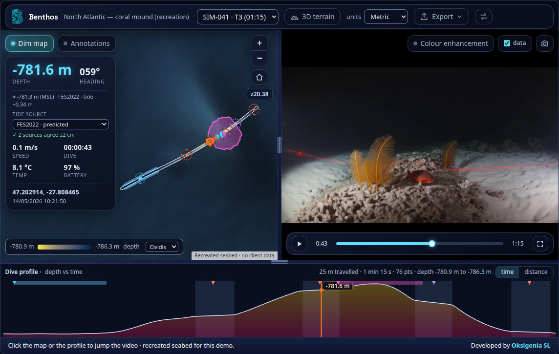
Illustration: the BenthosLite desktop window, which is the Benthos viewer in read-only mode (map, video, dive profile), with a "signed, verified" seal in the title bar.
07 Security & control
Your data stays yours
Benthos is installed for your institution, on your infrastructure or on infrastructure you choose. There is no shared multi-tenant cloud behind it.
- One installation per institution. Your servers, your jurisdiction, your backups.
- Two-factor sign-in. Hardware security keys (WebAuthn, e.g. YubiKey or Nitrokey), authenticator apps, email codes.
- Roles for administrators, editors and viewers.
- Storage where you decide. Your own server, or Backblaze B2, Bunny or Cloudflare Stream.
08 Who it is for
Built for the people who go and look
-
Research centres
Long-term monitoring across campaigns and years. Consistent vocabularies, tides and exports, so the 2026 transect compares with the 2031 one.
-
Universities
One installation, unlimited users. Students annotate, supervisors review, the institution keeps the data.
-
Marine & geo survey companies
Faster from field to deliverable. Hand the client a signed BenthosLite package instead of a folder.
-
Technology companies in the sector
A data-agnostic layer to put your sensors' output in front of the people who use it.
09 Vision
Knowledge that compounds
Most survey data piles up: a folder per campaign, a drive per year, and the picture of the place never quite comes together. Benthos is built so that each new survey builds on the ones before it — on the same track, in the same vocabulary, on the same map.
The aim is a living map of the unknown, one that grows more coherent with every expedition.
- RoadmapAI-assisted reconstruction
- RoadmapPositioning without GPS from photogrammetry and LiDAR
10 Next
See it on your own survey
Bring a transect, a track and, if you have it, a terrain model. We show you what Benthos does with them.